Australia headed for hot and dry spring after unseasonably warm winter
Almost all of Australia will experience unusually warm temperatures and lower than average rainfall this spring, according to the Bureau of Meteorology.
The bureau’s outlook for spring reveals that while an El Niño has not been formally declared, the climate will still be drier and hotter than usual.
“After what looks to be our warmest winter on record, spring is also likely to bring warmer days and reduced rainfall,” said the bureau’s senior climatologist, Lynette Bettio.
“Most of the country has a high chance of daytime temperatures that are warmer than usual, this spring. There’s an increased chance of unusually warm days for almost all areas, especially in Western Australia and parts of the south east.”
Bettio said winter rainfall was about 8% below average with warmer temperatures reported everywhere apart from the south-east of Western Australia. The national mean temperature was about 1.5C higher than average.
This spring will be very different to last year, according to Bettio, who said the 2022 season was “the second wettest on record”.
“The first rains of northern Australia’s wet season are likely to be lighter than normal, especially for the Northern Territory and Queensland,” she said.
Last week, the Australasian Fire Authorities Council urged communities to prepare for what is likely to be the most significant bushfire season since the 2019-20 black summer fires.
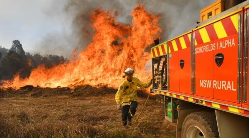
Large swathes of Australia are likely to experience an “increased risk” of bushfires due to forecasts of above-average temperatures, decreased rainfall, high fuel loads and changing weather patterns.
There is a chance of a higher number of bushfires occurring that require pre-emptive management and firefighting compared with the average. Areas at increased risk include regions in Queensland, New South Wales, Victoria, South Australia and the Northern Territory.
Bettio said Australia’s water storages were close to 80% full with many close to 90%. But she said some were now dropping below 50% and were likely to drop further.
While the World Meteorological Organization and the US National Oceanic and Atmospheric Administration have already said an El Niño is in place, the bureau has remained at alert level.
El Niño is characterised by high ocean temperatures in the equatorial Pacific that weaken the east to west trade winds that blow over the ocean. This climate pattern can drive droughts and heat in Australia, and can push up global temperatures.
“We remain at El Niño alert as it is likely an El Niño will develop this year,” Bettio said. “Sea surface temperatures are forecast to keep warming above El Niño levels.”
“July was the warmest month on record globally when including land and ocean temperatures. We know that a warmer climate increases the risk of extreme weather like heat waves.”
Photograph: Darren England/AAP - New South Wales Rural Fire Service firefighters conduct back burning in NSW. Authorities are warning of ‘increased risk’ of bushfires due to forecasts of above-average temperatures, decreased rainfall, high fuel loads and changing weather patterns.