Burn Scars Can Exacerbate Flooding, Posing Compounding Climate Hazards
Wildfires can burn so hot that they give rise to water-repellent soil, which could make ecosystems more susceptible to flooding.
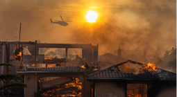
Southern New Mexico was already parched by drought when the South Fork fire ignited on June 17, 2024. The blaze burned roughly 17,000 acres near the town of Ruidoso in the Lincoln National Forest and the Mescalero Apache reservation, killing two people and destroying 1,400 structures.
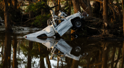
Since then, several disasters have hit in the scars left by the flames. Most recently, on July 8, torrential rain triggered flash flooding that inundated the village of Ruidoso, killing three people, including two children. In just 30 minutes of downpour, the Rio Ruidoso river swelled to around 20 feet high, a record.
While this level of rain can be dangerous on its own, the burn scars exacerbated the deluge. Research shows that intense fires can burn through vegetation and alter soil in a way that repels off water, increasing the risk of debris flows or mudslides for years, particularly in mountainous areas. As these compounding threats become more common with climate change, communities are struggling to secure long-term support.
Soil Shifts: Typically, soil and vegetation act as sponges during a storm, soaking up much of the water that falls from the sky or slides down a hill. Low-intensity fires—a natural part of many ecosystems—can actually add organic matter to soil and reduce the chance of rain-related runoff.
The trouble starts when wildfires get hotter and more severe. Sometimes topping 1,000 degrees Fahrenheit, these blazes burn completely through vegetation and can create a waxy coating on soil that’s as “water repellant as pavement,” according to the National Weather Service.
During a storm, these conditions increase the risks of fast-moving landslides known as debris flows, which carry a slurry of mud, rocks, boulders and other sediment like the mixture that hit New Mexico earlier in July. When the flows travel downhill, they can move at the speed of a freight train, according to Jen Pierce, a professor at Boise State University’s Department of Geosciences.
“Even during very run-of-the-mill storm events that normally would never cause floods, that water can’t soak in like it used to be able to,” Pierce told me. “Of course it needs to go somewhere, and it runs off. So then, if you combine severely burned soil surfaces with steep topography and an intense rainstorm, then that’s what produces those flash floods.”
The threat can last for several years but is typically greatest during the first two years after a fire. These events have hit wildfire-prone regions hard in recent years. In 2018, extreme rain fell over a previously burned area in Montecito, California, and formed the deadliest debris flow in the state’s history, killing 23 people and damaging more than 400 homes. Communities in Los Angeles County near the burn scars left by January’s fires have been hit by multiple debris flows, The Associated Press reports.
Inside Scoop: My colleague Martha Pskowski visited Ruidoso last week and witnessed some of the damage left behind by the floods. I asked her what she saw. She reported back:
Ruidoso is a popular vacation destination where I live in El Paso, Texas. I watched footage of the fires in disbelief, recognizing places I had visited. But the community’s challenges were only just beginning.
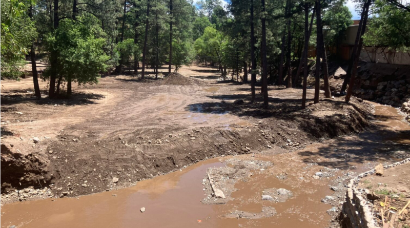
Here in the Southwest, most of the annual rainfall comes during the monsoon season from July through September. Burn scars formed where the fire had scorched vegetation and soil. Flash flooding began last year and has continued this summer. Rain water rushes down the bare mountainsides and fills Rio Ruidoso, which runs through the center of town.
On July 8, between 2.5 and 3.5 inches of rain fell. A wall of water came rushing down the canyons into Rio Ruidoso, flooding an RV park in the area.
When I visited Ruidoso this past weekend, evidence of the floods was shocking. There were trailer homes stained by muddy water, RVs and trucks bent out of shape, uprooted trees and branches piled against buildings with shattered windows. Meanwhile, other parts of town on higher ground appeared untouched.
Walking by the banks of the Rio Ruidoso on a sunny Saturday, it was hard to believe this small river could swell high enough to wash away buildings and claim lives. But that’s just what had happened less than two weeks earlier.
The ordeal isn’t over. Every time it rains, Ruidoso braces for another flood.
Zooming Out: According to a 2023 analysis, more than 21.8 million Americans lived within three miles of a large wildfire over the last two decades. As many of these communities reel from the impact of the flames, they must also prepare for future threats like floods, representing what researchers call compound climate hazards. Another example is when hurricanes fuel wildfires by downing trees that are more likely to dry out and ignite, which I wrote about in March.
These compounding disasters can strain already limited resources for disaster recovery. For wildfires, much of the federal assistance comes shortly after a blaze is put out, but funds are rarely enough to support mitigation for long-term risk like floods in burn scars, The Deseret News reports. Communities could benefit from infrastructure like channels that can help contain and funnel debris flows or aerial seeding that can promote the regrowth of native vegetation, Boise State University’s Pierce said.
“As we have increasingly warm and dry temperatures every year, the likelihood of the fires and post-fire debris flows will increase,” she said. Though these events can be tough to predict and respond to, Pierce said that “if you can get a root in the ground, then that should help.”
Cover photo: The Rio Ruidoso runs through Ruidoso, New Mexico on Saturday, July 19. Debris has been cleared from some areas along the river after deadly flash floods on July 8. Credit: Martha Pskowski/Inside Climate News