Eastern Australian states hit by major flooding after ‘rain bomb’ weather event
Eight dead and hundreds rescued from rooftops as rainfall exceeds annual averages in just a few days
The flood broke through the levee before daybreak. By the time many residents of Lismore in northern New South Wales woke up on Monday, the water had begun to lap at their doorsteps.
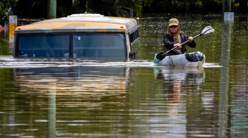
Those unable to flee climbed on to upper levels of their homes, then out on to their rooftops. Hundreds were rescued by boats and kayaks and jetskis; many others are still unaccounted for.
Artist Lucy Vader began calling for help on her social media page at about 7am. A few hours later as she waited for rescuers, she posted a video of herself sitting on the roof as the flood continued to rise.
“I’m on my roof, the water is still rising, my dog is stuck inside my house,” she said, the rain beating on to the tin roof.
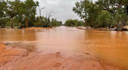
The storm battering Australia’s east coast is again being described as “unprecedented”; the weather system sat over Brisbane, the country’s third-largest city, for more than three days. The rain has been fierce and has continued, unabated. In some parts of the city, more than 1.5 metres of rain – close to the average annual rainfall – has come down since Thursday.
Eight people have died, all in Queensland, while police hold grave fears for at least three more who are missing.
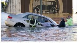
On Sunday afternoon a 59-year-old man was killed while attempting to cross a flooded road on foot at Taigum, in Brisbane’s outer north. Police said witnesses had attempted to give the man CPR but he died at the scene.
A man believed to be in his 50s is also presumed dead after his car was washed away in flood waters in the Currumbin Valley, near the NSW border, early on Monday. Police said they believe the man’s vehicle was driven about 30 metres along a flooded road. The vehicle has not been found.
Having dumped on Brisbane, causing widespread flooding that authorities estimate may have caused damage to about 15,000 properties, the weather system finally moved south early on Sunday, giving the Queensland capital a chance to take stock of the damage.
As the rainfall shifted, so did the flood threat. Northern NSW river towns of Murwillumbah and Lismore are both under water with the NSW premier, Dominic Perrottet, warning worse is to come.
Lismore is a community that has become used to flooding. The last time the levee broke, in 2017, was during ex-tropical cyclone Debbie.
Locals in Lismore still talk about the 1954 flood. The rain started the same day a young Queen Elizabeth visited the town in northern NSW and the Wilsons River eventually peaked at 12.15 metres – a height that had not been exceeded in almost 70 years.
On Monday, the same river peaked more than 2 metres higher than ever before – at 14.46 metres. Videos show the town’s two-storey shopfronts inundated to their roofs.
Northern rivers local John Vanderstok, who joined a flotilla of private boats rescuing residents trapped in flooded homes across the town today, said authorities had been overwhelmed by the scale of the rescue operation.
“The emergency services are around but I’d say the locals outnumber them 20 to one, anyone who has a boat is just out there trying to save anyone they can. It’s just so sad, so terrible for the people trapped,” Vanderstok said.
“There would have been – hanging out windows, on roofs – hundreds. There are people everywhere and there are also a lot of boats. I reckon about 200 to 300 boats are there – even heading back, I passed another 15 boats heading in.”
Perrottet said the situation will likely deteriorate.
“The advice that we have received is that we would expect things to get worse over this period of time,” he said on Monday. More than 60,000 residents have been told to prepare to evacuate.
“Simply because your community has not flooded in the past does not mean that it will not flood over the course of this week. What we are seeing today is unprecedented.”
Heavy rain in Brisbane finally eased about midnight on Monday, removing some of the strain that had choked suburban floodways and dumped record volumes into dams.
Within hours of the rain stopping, suburban flooding caused by swollen creeks and Brisbane River tributaries largely subsided, and people were able to return to their homes to assess the damage.
“We left about 3pm yesterday, the water was up to here,” said Nirin Giri, pointing to a spot just below the front balcony of his home at Newmarket, in Brisbane’s inner north.
The surrounding houses on Ashgrove Avenue, near the bridge over Enoggera Creek, all suffered significant damage. The water overturned a large garden shed in a neighbour’s yard.
“There’s mud right through [the house], you can see it has come right up along the wall there,” Giri said. “We are not alone, this has happened to everybody.”
At the same time as people in Brisbane’s suburbs were returning to their homes, the Brisbane River reached its peak, causing inundation of low-lying banks, including parts of the CBD, Southbank and West End.
Meteorologists say while several features in the atmosphere combined to deliver the extraordinary rain event over south-east Australia, climate change likely made the event worse.
“Given climate change is a background to all weather events, it’s hard to say that it does not play a role. We know the oceans are getting warmer and that puts more moisture in the atmosphere, and a warmer atmosphere can hold more moisture.”
The Australian Bureau of Meteorology has said that heavy rainfall events will get more intense as the world gets hotter.
While heavy rainfall has finally eased, concern remains about storms forecast for later in the week which might cause further chaos if river levels are still high.
Diana Eadie from the Bureau of Meteorology said those storms posed an additional risk. “That really intense rain is now shifting into north-east New South Wales and is easing for much of south-east Queensland,” she said. “That being said, the risk for significant flooding is still very real.
“We’re expecting more settled conditions today and continuing into tomorrow. From Wednesday onwards and the following five days, we see a return of the potential for severe thunderstorm activity with the risk of damaging winds, large hail and locally heavy falls.
“We’re not expecting widespread rain as we have seen in this event, but with any severe thunderstorm, there is the potential that we could see very intense rainfall rates in some localised areas.”
The Queensland premier, Annastacia Palaszczuk, said there had been “a huge response effort”.
“It has been fast and it has been furious and it has had a big impact,” she said.
“I don’t know about everyone else, but last night it was like cyclonic conditions outside. The winds, the rain and … we had two systems of thunderstorms merging last night as well during the course of the day. We didn’t know that was going to happen.”
cover photo: The storm battering Australia’s east coast is again being described as ‘unprecedented’. Photograph: Patrick Hamilton/AFP/Getty Images