Fifteen Years After Largest U.S. Offshore Oil Spill, Researchers Reveal Most-Polluting Rigs
Satellite imagery shows the worst sites worldwide for oil slicks and methane emissions. Report authors expect pollution will only increase as the Trump administration opens more waters to drilling.
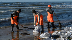
April 20 marked 15 years since BP’s Deepwater Horizon rig exploded, releasing 134 million gallons of oil off the coast of Louisiana in the country’s largest oil spill.
Oil gushed for nearly three months, covering an area on the surface of the water the size of Oklahoma. The spill devastated fisheries, seabirds, turtles, whales and endangered species. Scientists are still studying the lasting harms today.
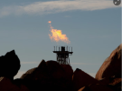
Days after the anniversary, the environmental nonprofit SkyTruth published its latest white paper, naming the top polluting offshore oil rigs in the world while calculating their environmental costs in spilled oil, greenhouse gas emissions and methane flaring.
Despite clear evidence that oil spills are an ongoing problem, the U.S. has only increased offshore drilling since then. Last month, the Trump administration launched the five-year process for selling new oil and gas leases, including new areas off the coast of Alaska. At the same time, President Donald J. Trump signed an executive order to sunset rules for all new and existing offshore drilling regulations, among them those passed after the Deepwater Horizon spill aimed at preventing another such underwater rupture.
Trump’s new budget proposal would also slash funding at the National Oceanic and Atmospheric Administration for satellite research, making it harder for organizations like SkyTruth to monitor offshore oil pollution.
In 2010, John Amos, a geologist and founder of SkyTruth, watched the Deepwater spill grow from his basement home office in Shepherdstown, West Virginia. Insteading of looking at the TV, he pulled up NASA satellite imagery. Amos, originally trained in analyzing satellite data to find prime drilling sites in the ocean, now used those same skills to see just how far and fast the slick was spreading.
He suspected the extent was much larger than estimates from the Coast Guard and BP. “I remember being terrified,” Amos said. “I wanted to help and get information out as fast as possible so the Coast Guard could have it.”
In a blog he posted on April 27, 2010, Amos shared satellite images and annotated maps. The post went viral and soon Amos was on the news, explaining his calculations for measuring the true size of the spill. Months later, the federal government upped its estimate of the oil flow rate to 53 times higher than their original numbers.
Amos and SkyTruth have continued monitoring satellites to observe all types of pollution from offshore oil and gas drilling. In their white paper, published April 23, researchers examined satellite imagery between June 2023 and October 2024, and estimated 20 offshore oil facilities accounted for nearly 300,000 gallons of oil released during that time.
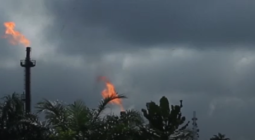
Ships that visited offshore facilities were responsible for 9 million tons of carbon emissions in 2023. That same year, methane flaring by offshore facilities emitted 58.7 million metric tons of CO2 equivalent emissions, according to the report.
While monstrous spills make the news, chronic oil pollution often goes under the radar. “Conservatively, we think the amount of oil going into the ocean each year rivals the BP spill in size,” Amos said. That’s because satellite coverage of the ocean typically has multi-day gaps for a given location and most spills will dissipate and become undetectable within 24 hours, Amos said.
Amos and his team used AI-powered software called Cerulean that automatically scans European Space Agency satellites Sentinel-1 and Sentinel-2 for oil slicks. Then, they reviewed each image by hand.
To estimate the volume of each slick, SkyTruth used an estimate based on the minimum average thickness that makes an oil slick at sea visible on radar satellite imagery. Based on its research, SkyTruth has settled on one millionth of a meter as a “conservative rule of thumb.” The actual volume is likely substantially higher, the report says.
“The top polluters we found, sadly, were no surprise,” Amos said. Those include sites run by Chevron, Exxon and Shell. Shell’s office declined to comment, and Chevron and Exxon did not respond to multiple requests from Inside Climate News.
Out of all floating and fixed drilling sites SkyTruth examined, the worst three were in Indonesia, Nigeria and Cameroon, with estimates of oil slick volume ranging from 15,280 to 44,240 gallons released over the 16-month monitoring period.
Increasingly, oil drilling is happening farther and farther from land, “over the horizon and out of sight,” said Christian Thomas, geospatial engineer and lead report author. “If people are unaware of what’s happening, there’s no pressure to change.”
Thomas hopes SkyTruth’s data will prompt enforcement agencies to check on polluting sites and lead to the introduction of legislation that protects coastal and marine communities.
“Having real observations and data on what’s going on with air pollution, climate pollution and water pollution is just absolutely essential to show the real extent of the harm,” said Rebecca Loomis, a project attorney at the Natural Resources Defense Council.
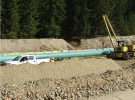
As near-shore wells become depleted, floating vessels make it easier and cheaper to drill in deeper waters. In 2024, the majority of new large-scale oil and gas extraction projects were located offshore, and that’s only expected to increase: The offshore drilling market is projected to grow from $44 billion in 2025 to $69 billion by 2032, according to Fortune Business Insights.
“New offshore oil and gas in particular threatens to lock us into fossil fuel production and associated greenhouse gas emissions for decades to come,” Loomis said. From the time a project is approved to the time it actually starts producing oil or gas can take upwards of seven years, according to the American Petroleum Institute. Then, leases stay active for decades.
Instead, that money could better be used to invest in renewable energy, Loomis said. Offshore wind, for example, has shown remarkable increases in productivity in recent years. New innovations, like floating platforms for wind turbines, allow access to strong winds that produce more consistent energy.
President Trump, however, is vehemently opposed to wind energy and ordered a pause on all onshore and offshore permits and loans his first day in office. In response, seventeen states, plus Washington, D.C., are now suing the administration.
In addition to ongoing greenhouse gas emissions from drilling, oil spills have major economic impacts. That’s why Virgnina lawmakers banned all offshore drilling in 2020, in order to protect the Chesapeake Bay, the nation’s largest estuary. Lawmakers on both sides of the ballot were largely convinced by looking at financial impacts, said Jay Ford, Virginia policy manager at the Chesapeake Bay Foundation.
A spill would not only devastate the state’s fisheries, central to the regional economy, but would interfere with sensitive naval and military operations. “It was a no-brainer for us to say, this is a terrible idea for a fuel source we’re trying to transition away from,” Ford said. Offshore drilling “ends up having tremendous ripple effects in other economic sectors that clean energy just doesn’t.”
Under the new federal rules, drilling could become even riskier.
Among the regulations on the chopping block is one implemented after the Deepwater spill, designed to increase safeguards around wells to ensure that another rupture doesn’t happen. The order directs the Interior’s Bureau of Safety and Environmental Enforcement to “suspend, revise, or rescind” the rule.
If blowouts do happen, monitoring those spills via publicly accessible satellites could become a thing of the past. President Trump’s newly proposed budget would cut $209 million from the National Oceanic and Atmospheric Administration’s satellite program. The cuts would cancel “contracts for instruments designed primarily for unnecessary climate measurements rather than weather observations,” according to a White House memo.
That would not only make it much more difficult for scientists to conduct climate and water research, but also for the public to access that data firsthand—as Amos did when he first exposed the severity of the Deepwater spill.
“I think we have a real chance to put an end to intentional oil pollution at sea with public visibility and public pressure,” Amos said. But to do that, “we need more publically accessible earth observation satellites.”
“Deepwater Horizon was not the last catastrophic oil spill we’re going to see, I’m certain of that,” he said. “This is going to continue to happen as long as we keep drilling for oil offshore.”
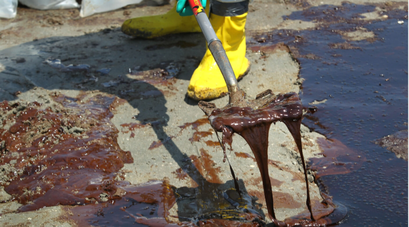
Cover photo: A BP cleanup crew shovels oil from a beach on May 24, 2010 at Port Fourchon, La. Credit: John Moore/Getty Images