What will climate change look like near me?

How much rain might fall in your area and how high might temperatures climb? The BBC and the Met Office have looked at the UK's changing climate in detail to find out.

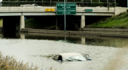
The UK is already experiencing increased rainfall and higher temperatures, and these extreme weather events are likely to become even more frequent.

The Met Office climate projections cover different levels of global warming. When, or if, these levels are reached will depend on the concentration of greenhouse gases in our atmosphere.

The data is measured in 12km-square (7.5-mile-square) grids across the UK. The results for your postcode represent an average for the grids closest to you and the mid-point of a range of future possibilities.

How could the climate change near you?

Average daytime summer temperature, UK

4C global warming

DC

The Met Office climate projections for the UK indicate significant temperature rises in the decades ahead for both winter and summer, with the greatest increases in the already warmer South.

Extreme weather could become more frequent and intense.

Not every summer will be hotter than the last – but temperature records are expected to be regularly broken, while heatwaves are likely to be longer and happen more often.

Total winter rainfall, UK

4C global warming

V

The UK climate projections suggest increases in winter rainfall in most parts of the country, as well as drier summers.

Rainfall measurements fluctuate from year to year, making projections challenging.

Not every winter will necessarily be rainier than the one before, and not every summer will be dry, but both trends could have big impacts.

What difference will climate change make?

As the world warms, the UK is likely to have hotter, drier summers and warmer, wetter winters, according to the Met Office.

Extreme weather events such as heatwaves and heavy downpours could become more frequent and more intense. Many scientists are concerned.

"I think it's really frightening," says Dr Lizzie Kendon, a senior Met Office scientist. "It's just a wake-up call really as to what we're talking about here."

We are already seeing the impacts of climate change, but the level of global warming we reach and by when will depend primarily on the concentration of greenhouse gases in the atmosphere.

To some, warming weather may not seem like such a big deal. But even the smallest incremental changes in climate can have far-reaching effects.

Temperatures above 30C for two or more days can trigger a public-health warning. In the 1990s, this happened about once every four years for locations in the South. By the 2070s, projections suggest it could be as frequently as four times per year - 16 times more often, if we do not curb our emissions.

What about farming?

Agriculture has been described as being on the front line of climate change, the first to feel its impacts.

This year was a bad one for British farms. And while many crops suffered, wheat production faced its worst yield in at least 30 years, according to Tom Bradshaw, deputy president of the National Union of Farmers.

On one of the farms Mr Bradshaw oversees, he attributes bean-crop losses to extreme weather patterns, which "completely messed the crop up from the start".

A wet winter prevented his plants from developing healthy roots and a hot dry summer stunted their growth.

The Met Office projects rainy winters, which keep the soil wet into spring, and dry summers of infrequent rainfall will become the norm.

More floods, less snow?

Summer rain is likely to become less frequent but could be heavier. Without regular rainfall, the ground has a harder time absorbing water when it finally does come, leading to a greater risk of flash flooding.

Floods will likely become a staple of warming winters as well.

Steady rain, which is currently a feature of winter months, will probably continue, and total rainfall is expected to increase.

When the ground is already saturated, waterways tend to rise. Bridges and sewers designed for historical rainfall levels may come increasingly under pressure.

Warming temperatures could also mean cold spells become less frequent.

And snowy UK winters could become thing of the past as climate change affects the UK, according to Met Office analysis shared with BBC Panorama.

Temperatures below freezing during the day and areas with considerable amounts of snow on the ground may be limited to parts of Scotland by the end of the century if emissions continue to rise.


Right now the world is about 1.2C warmer than it was at the end of the 19th Century, with significant impacts all over the planet.

That warming has been caused by greenhouse gas emissions, that have ramped up over the last 50 years, from the global growth in industry, transport and agriculture.

The real problem is that gases like CO2 hang around in the atmosphere for centuries, warming all the while. Not even a pandemic could stop their build up.

So where will all this warming stop?

Well, recent promises by major emitters including China, the EU and others to reach net-zero carbon emissions by the middle of this century are good news.

Scientists believe that if the pledges are kept, then warming could be limited to 2.1C.

But even that level of warming promises great danger, destroying all the coral reefs and threatening wide swathes of the world with flooding.

If the promises aren't kept, then warming could rise to between 3C and 5C, with truly disastrous implications for our planet.

Methodology

Where is the data from?

The BBC has collaborated with scientists from the Met Office to analyse data from their extensive weather measurement records and their major climate modelling project, the UK Climate Projections (UKCP).

The present-day data shows averages of observed measurements for 1991-2019.

The future data shows projected temperature and rainfall measurements produced by climate models for two different levels of global warming: if global average temperatures rise 2C above records from the mid-19th Century, the start of major industrialisation, and if that rise is 4C.

Twelve different versions of the Met Office's Hadley Centre climate model were used in calculating the UKCP Regional (12km) projections using a high emissions gas scenario (RCP8.5).

Climate models are computer simulations of how the atmosphere, oceans, land, plants and ice behave under various levels of atmospheric greenhouse gas concentrations. They help scientists come up with projections for what conditions on Earth we are likely to see as global warming continues.

Which future level of global warming is more likely?

The level of global warming depends on a number of factors. The most important is the amount of emissions produced in the coming years.

Emissions are greenhouse gases released into our atmosphere. The accumulation of these gases has a warming effect on the globe, which in turn leads to changes in climatic conditions.

Governments around the world have pledged to reduce their emissions to limit the degree of warming.


The most recent of these pledges was the 2016 Paris Agreement in which world leaders committed to take action to keep a rise in global temperatures this century well below 2C above pre-industrial levels. In climate models, this 2C rise by the end of the century represents sizeable cuts in global emissions.

If no interventions are taken, global average temperatures could rise by up to 4C by 2100. This high-emissions future is highlighted in the most recent Evidence Report for the UK's Climate Change Risk Assessment (CCRA) as possible, if less likely.

At current rates of global emissions, the world is on a pathway somewhere between 2C and 4C.

When will we reach 2C and 4C global warming?

The modelled projections in this data do not represent a specific time period. Instead, they show what conditions could be like in these two different levels of global warming.

Some other climate data may project specific points in time by which a certain level of global warming may be reached.

However, this model allows for the possibility of actions that may reduce or increase emissions enough to change the timing before we would experience a 2C or 4C future.

More information on the methods used to calculate the timing of different levels of global warming can be found in this 2018 Met Office paper.

What does this data measure?

This tool presents six different measurements among those scientists use to gain a picture of the environment under various conditions. Each represents a specific predefined climate metric.

1. Hottest day is the maximum temperature recorded or projected on a single day

2. Summer days, as defined by the World Meteorological Organization (WMO), have a maximum temperature above 25C

3. Average daytime temperature is the average of daily maximum air temperatures over a season

4. Rainy days are when more than 1mm of rain is recorded. This excludes days that may have had very light rain or a heavy morning dew or mist

5. Wettest day is the maximum amount of recorded or projected rainfall on a single day

6. Total rainfall is the amount in millimetres measured across a season. We also calculated and display the change in rainfall for the future scenarios as a percentage change from the current period (1991-2019)

What does ‘my local area' show?

Climate data is typically presented in gridded squares that make up a large surface area. The grids used in this model are 12km by 12km.

This level of detail is able to capture many of the varied climate conditions across the UK's diverse geography far better than other, broader-scale models.

Each UK postcode has been matched to its nearest 12km-square grid. The results displayed for your area represent an average (mean) for the grids closest to that location, as long as they are no further than 34km away.

In most cases a grid has been averaged with its eight nearest grids, except along irregular coastlines and small islands.

Averaging means that the figures displayed are never for a single grid alone. While natural variability between grid areas is normal, this process minimises dramatic differences that may be down to chance.

What do the current and future data represent?

Both current and future data are organised into the same 12km-square grids.

However, unlike future modelled predictions, the present-day data comes from actual observed measurements.

We have presented a single number that represents an average for each grid and season. This helps to reduce the influence of outliers in observed data.

For instance, the current number of summer days represents the mean number of days recording maximum temperatures of at least 25C per month in June, July and August across every year from 1991 to 2019.

Each number presented in the two future scenarios represents the median of 12 possible outcomes as projected by the 12 model simulations.

All future projection data has been calibrated by Met Office scientists against the data in the present-day range, 1991-2019, so the model results can be compared directly with observations. More information on the calibration technique used can be found in this 2017 paper.

Why do the maximum temperatures not match what I saw on the news?

Because climate data is gridded, the data may represent a larger area than that covered by a single weather station. Measurements from multiple weather stations are averaged together to give a single datapoint for a grid.

Take the hottest day, for instance. If the highest temperature recorded at Cambridge Royal Botanic Gardens was 38.7C, that number is combined with measurements from other stations across the region to produce an average for a 12km-square area that includes Cambridge. Other weather stations will have recorded slightly lower temperatures, so the average highest temperature in this area would be less than 38.7C.


Credits

Data analysis and production by Becky Dale, Nassos Stylianou and Alison Benjamin. Design by Zoe Bartholomew, Debie Loizou and Prina Shah. Development by Becky Rush, Alexandra Nicolaides and Catriona Morrison. Editorial support from Joseph McAuley and Paul Rincon. Data and analysis guidance from the Met Office: Dr Dan Bernie, Dr Elizabeth Kendon, Prof Jason Lowe OBE, Dr Mark McCarthy and Dr Fai Fung. Special thanks to the Met Office's Oli Claydon, Grahame Madge and Joanne McLellan, the BBC's head of statistics Robert Cuffe as well as Dr Sihan Li at the University of Oxford Environmental Change Institute.


F